Best Offline Survival Maps 2026-2027: Topo, Elevation & Emergency Map Apps Tested
We tested the best offline survival maps for 2026-2027 in airplane mode. Compare topo terrain, flood elevation, emergency POIs, hazard layers, and which apps still work when cell towers fail.
Most "best offline maps" roundups pick a hiking winner and stop there. That is the wrong test for survival.
A trail app can show you a blue line when you have signal to plan. A survival map has to answer harder questions with zero bars: Where is higher ground in a flood? Where is water, medical care, or shelter nearby? How far am I from a hazard? What do I do next if I am injured, lost, or sheltering in place?
This guide ranks offline map apps for 2026-2027 on that survival standard, not on who has the prettiest trail social feed. For product depth beyond this ranking, see HAVEN offline maps features.
> Quick Answer: For offline survival maps (topo + elevation + emergency POIs + crisis guidance in one app), HAVEN is the best pick for most people in 2026-2027 at $24.99 one-time. Gaia GPS still leads specialized recreational overlays (parcels, avalanche slope). OsmAnd and Organic Maps win if you only need free OpenStreetMap navigation. AllTrails+ and Google Offline are trail/city caches, not survival systems.
Download HAVEN free and test your region in airplane mode tonight. If it passes, Pro unlocks multi-region packs for a one-time $24.99 - no yearly map tax.
Best offline survival map apps compared (2026-2027)
| App | True offline topo / terrain | Survival layers (POIs, elevation, hazards) | Emergency guidance beyond the map | iOS & Android | Typical cost |
|---|---|---|---|---|---|
HAVENDownload Free | Yes - 7 styles, Copernicus DEM hillshade & contours | Elevation shading (5/10/50m), emergency POIs, nuclear rings, Watch hazard polygons | On-device AI, 17 scenarios, library | Both | Free tier · Pro $24.99 one-time |
| Gaia GPS | Excellent - deep layer library | Strong recreational overlays; not crisis-protocol focused | Navigation-first; no crisis AI | Both | ~$39.99/year |
| OsmAnd | Strong OSM + plugins | Highly configurable; DIY setup | Minimal survival playbooks | Both | Free / paid unlock |
| Organic Maps | Good OSM offline | Clean basics; few survival-specific layers | None | Both | Free |
| AllTrails+ | Trail-focused offline | Established trails, not crisis terrain | Trail discovery, not emergencies | Both | Subscription |
| Google Maps Offline | Road/city tiles only | No real topo / flood elevation toolkit | Directions need data for many features | Both | Free |
How we scored "survival maps" (not hiking apps)

We cleared caches, enabled airplane mode, and scored each app on:
1. Offline depth - Does core map viewing, GPS position, and search work with no cell and no Wi-Fi?
2. Terrain intelligence - Contours, hillshade, elevation awareness for flood/tsunami higher ground.
3. Emergency usefulness - Shelters, water, medical, fuel, food POIs; hazard context; bug-out relevance.
4. Decision support - Does the app stop at "you are here," or help you decide what to do?
5. Price honesty - One-time vs subscription vs free with sharp edges.
6. Platform - iPhone and Android both matter for family kits.
1. HAVEN - Best overall offline survival map app (2026-2027)
Platform: iOS and Android
Price: Free core · HAVEN Pro $24.99 one-time · Family $34.99 one-time
Offline capability: ★★★★★
HAVEN's October 2026 Offline Maps overhaul rebuilt maps around crisis navigation, not social trails:
- Built-in global overview basemap, then downloadable regional packs before you leave signal
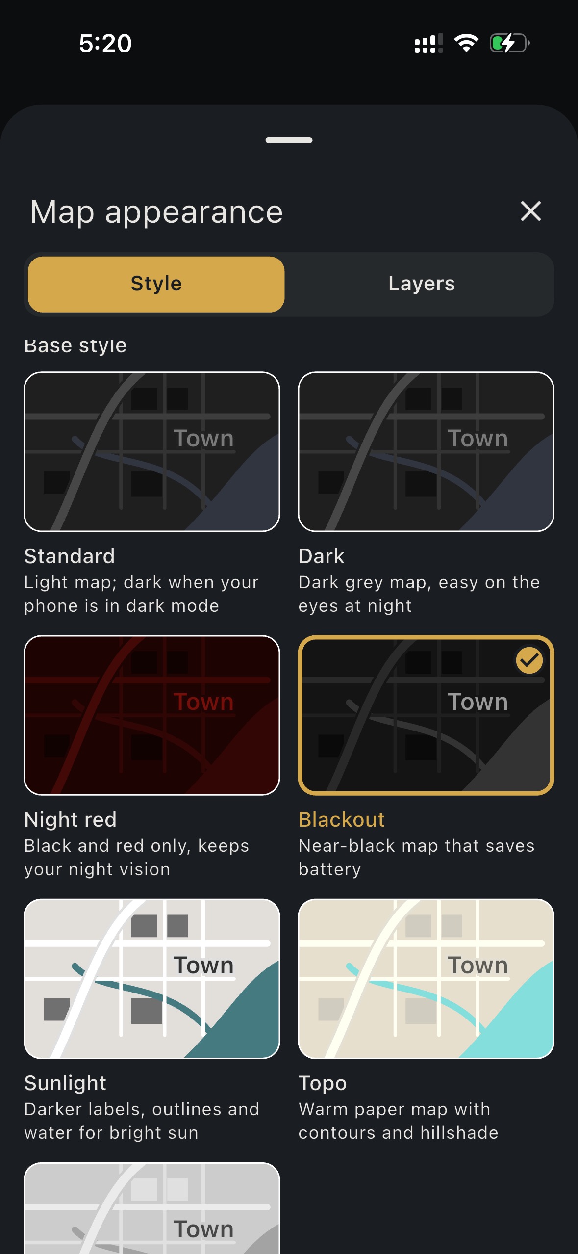
- 7 base map styles with live mini-map previews, plus Outdoors, Essentials, and Custom layer presets
- Terrain add-on: Copernicus DEM hillshade, contour lines, and 5m / 10m / 50m elevation shading for fast higher-ground decisions in floods and tsunamis
- Routes add-on: Offline hiking, cycling, and rail networks from OpenStreetMap
- Field tools: Waypoints, compass heading, GPS track recording with GPX export, QR sharing
- Emergency POIs: Shelters, water, medical, fuel, food (deduplicated for clarity under stress)
- Nuclear distance reference rings for planning context
- HAVEN Watch "See on map": Jump from a live alert to hazard polygons on the same map (Watch needs connectivity; the map itself still works offline once downloaded)
Maps alone would already put HAVEN in this ranking. What separates it for survival is everything around the map: on-device AI, crisis scenarios, first-aid and wilderness references, supply tracking, and Bluetooth mesh when towers are down.
Best for: Preppers, families building a bug-out plan, flood/tsunami coastal users, overlanders, and anyone who wants offline topo plus "what do I do now" guidance without a second subscription stack.
Download HAVEN free, download your region, then flip airplane mode on and verify GPS + layers before you need them.
2. Gaia GPS - Best specialized backcountry map library
Platform: iOS and Android
Price: Premium ~$39.99/year
Offline capability: ★★★★★ (navigation)
Gaia remains the benchmark for recreational map depth: USGS/NatGeo-style layers, slope and avalanche-oriented overlays, parcels/land ownership for hunting units, and excellent trip planning. If your primary job is technical off-trail navigation, Gaia still earns its keep.
Where it falls short for survival ranking: Gaia tells you where you are extremely well. It does not replace offline crisis protocols, on-device medical triage guidance, or a preparedness library. Over three years, Gaia Premium is roughly ~$120 vs HAVEN Pro's one-time $24.99.
Honest take: Serious backcountry travelers often run Gaia + HAVEN. See our full head-to-head: HAVEN vs Gaia GPS.
3. OsmAnd - Best free power-user OSM toolkit
Platform: iOS and Android
Price: Free with paid unlocks
Offline capability: ★★★★☆
OsmAnd is the Swiss Army knife of OpenStreetMap. Plugins, contour add-ons, deep offline routing, and almost endless configuration. Tech-comfortable users can build a strong offline stack for free or cheap.
Tradeoff: Setup time. In a real emergency you want presets that are already correct, not a settings maze. OsmAnd will not walk you through nuclear sheltering, water purification, or family check-ins the way a survival system does.
Best for: Advanced users who enjoy configuring maps and already carry separate medical/survival references.
4. Organic Maps - Best simple free offline map
Platform: iOS and Android
Price: Free (no ads)
Offline capability: ★★★★☆
Organic Maps is clean, privacy-respecting, and genuinely usable offline for OSM navigation. Excellent "second phone" or everyday travel map.
Tradeoff: It is not a survival product. Limited crisis-specific layers, no elevation decision toolkit for floods, no emergency AI, no scenario playbooks.
Best for: Lightweight offline navigation when you already have a dedicated survival app.
5. AllTrails+ - Best trail discovery (not a survival map)
Platform: iOS and Android
Price: Subscription
Offline capability: ★★★☆☆ (on marked trails)
AllTrails wins trail discovery and community conditions. Offline maps help on established routes. They were never designed for off-trail crisis terrain, flood elevation decisions, or wilderness medicine.
If you hike AllTrails weekly, keep it for planning, then add a survival layer. Full comparison: HAVEN vs AllTrails.
6. Google Maps Offline areas - Best for cities, worst for grid-down terrain
Downloading an "offline area" in Google Maps helps with city streets when roaming fails. It is not a topo survival map: weak wilderness detail, no flood elevation toolkit, and many features still expect connectivity.
Do not make Google Offline your primary bug-out map.
What a real survival map must do in 2026-2027
Use this checklist before you trust any app with your family's evacuation:
- Download before the crisis - Regional packs, terrain, and routes saved while Wi-Fi is strong
- Topo you can read under stress - Contours / hillshade, not just a cartoon trail line
- Elevation awareness - Know higher ground fast for flood and tsunami scenarios
- Emergency POIs - Water, medical, shelter, fuel without crowdsourced noise
- Works in airplane mode - Test GPS position with radios off
- Pairs with decisions - First aid, water, shelter protocols when the map is not enough
- Paper backup - Digital maps die with batteries; keep a waterproof local sheet and compass skill
HAVEN is built around that checklist. Hiking apps are built around weekend adventure, which is fine until the weekend stops being recreational.
Survival map scenarios that expose weak apps
Flood and coastal surge
You need elevation bands and higher-ground routes, not a 4-star hike review. HAVEN's 5m / 10m / 50m elevation shading is designed for that glance decision. Pair with our flood preparedness guide and tsunami warning signs.
Bug-out and infrastructure failure
Road closures, debris, and failed GPS assumptions are normal. Offline regional packs, rail/hiking alternatives, and emergency POIs matter more than curated trail lists. Build the kit with a family bug-out bag checklist, then map the corridor offline.
Backcountry injury with no signal
The map shows the ridge. You still need wilderness first aid steps. That is why offline survival apps and maps should live together, not as separate hopes. Hikers: also read backcountry phone essentials with no signal.
Overland and remote travel
Vehicle travel needs regional downloads before the dead zone, not a last-minute trail pin. See how to plan an overland route offline.
Watch-informed movement (when you still have data)
If you use HAVEN Watch, alerts can open live hazard polygons on the map. When connectivity dies, your downloaded maps and offline AI keep working.
Pricing reality check (3-year cost)
| Setup | Approx. 3-year cost | What you actually get |
|---|---|---|
HAVEN ProDownload Free | $24.99 once | Offline topo + terrain + routes + AI + scenarios + library |
| Gaia Premium | ~$120 | Best-in-class recreational map layers |
| AllTrails+ | ~$100+ | Trail discovery + offline trail maps |
| OsmAnd / Organic Maps | $0-$60 | Strong free/cheap OSM navigation |
Gaia + HAVENDownload Free | ~$145 | Navigation depth + survival intelligence |
For most households preparing for disasters, the highest ROI is HAVEN Pro first. Add Gaia only if you already live in technical backcountry navigation.
Our 2026-2027 recommendations
Best overall offline survival map: HAVEN
Best specialized topo library: Gaia GPS
Best free OSM navigation: Organic Maps (simple) or OsmAnd (power users)
Best trail planner: AllTrails (pair with HAVEN for emergencies)
Avoid as primary survival map: Google Maps offline areas alone
Get the map working this week
1. Download HAVEN on the phones that would actually leave the house.
2. Upgrade to Pro if you need multi-region packs and full offline tools ($24.99 one-time).
3. Download your home region, plus your bug-out route corridor, plus Terrain/Routes add-ons.
4. Enable airplane mode and confirm your position, elevation shading, and POIs.
5. Export a GPX of a practice walk so you know recording works under stress.
Optional gear pairing: browse the HAVEN Curated Survival Gear Shop for compasses, power banks, and go-bag basics, then track them in HAVEN Supplies.
Keep reading in this cluster
- HAVEN vs Gaia GPS - when you need both tools
- HAVEN vs AllTrails - trail apps vs emergencies
- Best offline survival apps 2026 - maps plus AI and scenarios
- Offline maps features - full product detail
Ready? Download free → verify airplane mode → unlock Pro for $24.99 once if your family needs multi-region coverage.
---
HAVEN is a product of Primecode LLC. Download HAVEN on iOS and Android. Maps are a preparedness tool, not a substitute for local emergency instructions or professional rescue.
FAQ
Q: What is the best offline survival map app in 2026-2027?
A: HAVEN ranks best for survival use: offline topo with Copernicus terrain, elevation shading, emergency POIs, and on-device crisis guidance for $24.99 one-time. Gaia still leads specialized recreational map overlays.
Q: Are offline hiking maps enough for emergencies?
A: Trail apps help on marked routes, but survival needs elevation awareness, emergency POIs, and decision support when you are injured, flooded, or off-trail without signal.
Q: Do HAVEN maps work with no cell service?
A: Yes. After you download regional packs and add-ons, map viewing, GPS position, terrain layers, routes, and track recording work in airplane mode.
Q: Do I need HAVEN Pro for offline maps?
A: The free tier includes limited offline map access so you can verify the product. Pro ($24.99 one-time) unlocks multi-region downloads and the full offline maps toolkit most families need for bug-out corridors.
Q: Is Gaia GPS better than HAVEN for maps?
A: Gaia wins for deep recreational layers like parcels and avalanche-oriented overlays. HAVEN wins when you need offline topo plus survival AI, scenarios, and emergency POIs without a yearly map subscription.
Q: What free offline map apps are best for survival?
A: Organic Maps and OsmAnd are the strongest free OSM options for navigation. They still lack HAVEN's crisis guidance stack, so use them as navigation supplements, not a full survival system.
Q: Should I still carry a paper map?
A: Yes. Batteries die. Keep a waterproof local map and compass skill as backup even if HAVEN or Gaia is your primary digital layer.
Ready to get prepared?
Carry on-device AI advice, offline topographic maps, and 12 printable field manuals on your phone with zero cell signal needed.